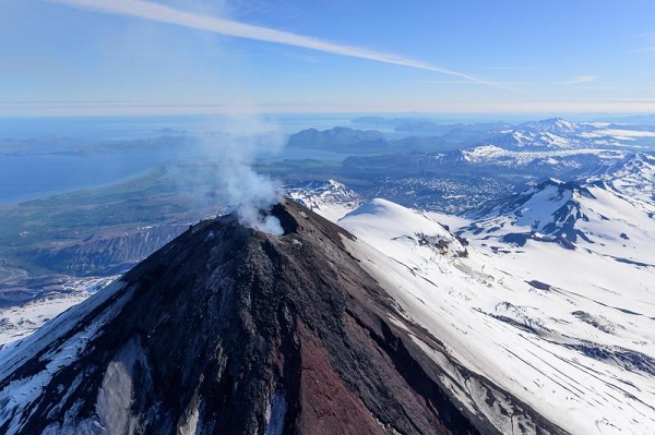
Pavlof volcano, July 23, 2017. View is toward the southwest. Photo credit: Chris Waythomas, AVO/USGS (AVO image ID 110781).
The Volcanology Section at the Division of Geological & Geophysical Surveys (DGGS) works within the larger context of the Alaska Volcano Observatory (AVO), a cooperative program established in 1988 between the U.S. Geological Survey (USGS), the University of Alaska Fairbanks Geophysical Institute, and DGGS. The USGS funds and administers the program to coordinate the mitigation of volcano-hazard risks to the public, state infrastructure, and air commerce. The Volcanology Section at DGGS plays a critical role in AVO by participating in eruption response, geologic and hazard assessment mapping, volcano monitoring, hazard communication, database and website design, and geologic sample archiving.
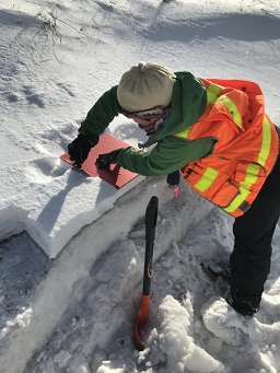
A geologist samples ashfall on Unalaska as a result of an explosive eruption of Bogoslof volcano in early 2017. Photo credit: Janet Schaefer, AVO/DGGS (AVO image ID 105781).
During an eruption, AVO staff participates in daily seismic and remote sensing data monitoring, contributes to eruption scenario forecasts, and keeps detailed records of ashfall, the eruption chronology, and the impact to air traffic and infrastructure. In addition, AVO staff responds to emails, gives interviews and community presentations, ensures the public website contains the most up-to-date volcanic information releases and photographs, and manages internal data flow.
Through its online services, AVO provides timely and accurate information on volcanic hazards, and warnings to local, state, and federal officials and the public of impending dangerous volcanic activity. AVO issues event-driven messages that require immediate action (such as warnings of immediate or ongoing eruptions), as well as less time-sensitive scientific publications and information about non-eruptive volcanic phenomena. DGGS-AVO staff also provides information via Facebook and Twitter accounts.
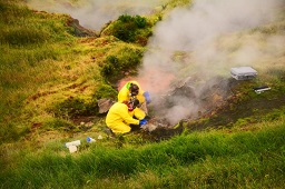
Volcanologists sample gases and water from the Geyser Bight geothermal area, Umnak Island in 2015. Photo credit: John Lyons, AVO/USGS (AVO image ID 83901).
The AVO conducts scientific investigations to better understand the nature, timing, and likelihood of volcanic activity and the hazards that may be posed. There are more than 100 volcanoes in Alaska, 54 of which have been active historically. Detailed geologic mapping of these volcanoes allows AVO to identify what types of volcanic events have occurred in the past, and helps make informed decisions regarding the likelihood and character of future volcanic events.
The backbone of the AVO website is the Geologic Database of Information on Volcanoes in Alaska (GeoDIVA), which is the most comprehensive and up-to-date source of information on volcanoes in Alaska. The AVO website and database functionality includes modules for bibliographic references, basic volcano information, eruption history, images, geologic sample catalog, sample geochemistry, internal communication, and other assorted volcanic observations. Related to this effort, DGGS-AVO staff develops applications for data management, as AVO is also tasked with inventorying and cataloging materials collected and analyzed by AVO scientists, making them available for future study.
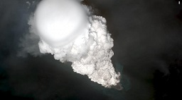
Worldview satellite image collected on May 28, 2017 showing an eruption cloud from Bogoslof volcano. Image credit: AVO/USGS (AVO image ID 109261).
In December of 2016, Bogoslof volcano, a small island in the Bering Sea, began erupting. More than 60 explosive events from Bogoslof occurred over the following year, keeping DGGS Volcanology Section staff busy. Bogoslof is located in the Aleutians, approximately 60 miles (100 km) from Dutch Harbor, and its eruptions resulted in occasional trace ashfall on Unalaska, as well as numerous flight cancellations in the area. AVO's eruption response tasks included remotely monitoring ash cloud movement via satellite data; monitoring seismic data; issuing aviation alerts; keeping records of eruptions, pilot reports, and volcano monitoring data; responding to media requests; and keeping the public informed of volcanic activity and hazards. During this eruption, DGGS-AVO staff developed an internal chat server that improved communication between AVO scientists and helped provide rapid volcano alert level changes to the public. In addition, AVO staff provided the community of Unalaska with ashfall preparedness presentations and numerous ashfall collection workshops.
Cheryl E. Cameron
Volcanology Section Chief
Phone: 907-451-5012
Email: cheryl.cameron@alaska.gov