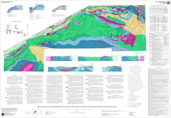
Twelker, Evan, Waldien, T.S., Newberry, R.J., Freeman, L.K., Sicard, K.R., Lande, L.L., Wypych, Alicja, Reioux, D.A., and Bachmann, E.N., 2020, Bedrock geologic map of the eastern Denali Highway area, Mount Hayes, Healy, and Talkeetna Mountains quadrangles, Alaska: Alaska Division of Geological & Geophysical Surveys Report of Investigation 2020-7, 1 sheet, scale 1:100,000. https://doi.org/10.14509/30469
 Maps & Other Oversized Sheets
 Geospatial & Analytical Data
These data products comply with our published AK GeMS standard. Download the ak_gems_db product to receive the full AK GeMS database and associated files. Download the gems_db (a.k.a. fed_gems_db) product to receive the data converted into the GeMS standard published by the USGS. Download the gems_shp (a.k.a. fed_gems_shp) product to receive simple shapefile representations of the data. For further information see the AK GeMS Database Project Page.
| Bedrock geologic map of the eastern Denali Highway area (Wrangellia) | Data File Format | File Size | Info |
|---|---|---|---|
| Download ri2020_007_wrangellia_ak_gems_db_pkg | Vector data | 24.4 M | Metadata - Read me |
| Download ri2020_007_wrangellia_gems_db_pkg | Vector data | 21.5 M | Metadata - Read me |
| Download ri2020_007_wrangellia_gems_shapefile_pkg | Shapefile | 2.6 M | Metadata - Read me |
Alpine Creek; Amphibolite; Amphitheater Mountains; Ann Creek; Archean; Basalt; Basalt Lake; Batholith; Bedrock; Big Rusty Creek; Black Creek; Boulder Creek; Broxson Gulch; Butte Creek; Cabin Creek; Cathedral Creek; Chistochina Mining District; Clear Creek; Clearwater Creek; Clearwater Mountains; Coal Creek; Coal Lake; Conglomerate; Copper; Corkscrew Creek; Correlation; Cottonwood Creek; Cretaceous; Crystal Lakes; DGGS; Delta River; Delta River Mining District; Devonian; Downwind Lake; Dude Lake; Eldorado Creek; Eocene; Eureka Creek; Eureka Glacier; Faults; Fielding Lake; Fish Lake; Fourteenmile Lake; Fourteenmile Lake; Garrett Creek; GeMS DB L3 Compliant; GeMS DB v1pt1; Geochemistry; Geochronology; Geologic; Geologic Map; Geology; Glacier Gap; Glacier Gap Lake; Glaser Lake; Gold; Granite; Granodiorite; Graphite; Greenschist; Greenstone; Grogg Creek; Grogg Lake; Gulkana River; Gunn Creek; Hatchet Lake; Hidden Lake; Hornblende; Igneous; Jarvis Belt; Jurassic; Lake Creek; Landmark Gap Lake; Limestone; Maclaren Glacier; Maclaren Glacier Metamorphic Belt; Maclaren River; Maclaren Terrane; Magnetite; Marble; McCallum Creek; McCallum Glacier; Metaigneous Units; Metamorphic; Metamorphic Minerals; Metamorphic Rocks; Metamorphism; Metavolcanic rocks; Miller Mine; Mineralogy; Minerals; Miocene; Moose Lakes; Mud Lake; Nickel; Nikolai Greenstone; No Good Lake; Norian; Nowater Creek; Octopus Lake; Oligocene; Orthogneiss; Osar Creek; Oxbow Lake; Paleozoic; Pass Creek; Pass Lake; Paxson; Paxson Mountain; Pennsylvanian; Permian; Petrokov Lake; Phalarope Lake; Phelan Creek; Platinum; Pliocene; Plutonic Hosted; Plutonic Rocks; Plutons; Precambrian; Quaternary; Raft Creek; Rainbow Mountain; Rainy Creek; Rainy Creek Basalt; Rainy Mountain; Rhyolite; Rock Creek; Rocks; Roosevelt Creek; Roosevelt Lake; Rusty Creek; Rusty Lake; Sandstone; Schist; Sedimentary; Sedimentary Rocks; Sevenmile Lake; Seventeen Mile Lake; Shale; Sillimanite; Siltstone; Silver; Skarn; Snodgrass Lake; Specimen Creek; Spray Creek; Staurolite; Strategic Minerals; Strategic and Critical Minerals Assessment Project; Strelna Formation; Strelna Terrane; Sugarloaf Mountain; Summit Lake; Surprise Creek; Susitna River; Swampbuggy Lake; Swede Lake; Tangle Lakes; Tangle River; Tenas Lake; Tephra; Tertiary; Triassic; Tuff; Two Bit Lake; Two Plate Creek; Ultramafic; Unconformity; Valdez Creek; Valdez Creek Mining District; Volcanic; Volcanic Rocks; Volcaniclastic Deposits; Volcaniclastics; Watana Creek; Waterfall Creek; White Creek; Wickersham Creek; Wildhorse Creek; Windy Creek; Wrangellia Terrane; geoscientificInformation


